Residual Strain despite Mega Earthquake
Even the strongest quake ever measured left energy for successors
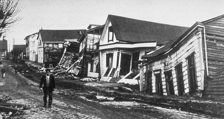
On 22 May 1960, an earthquake shook the southern Chilean continental margin on a length of about 1,000 kilometers. Estimates suggest that around 1,600 people died as a direct result of the quake and the following tsunami, leaving around two million people homeless. With a strength of 9.5 on the moment magnitude scale, the Valdivia earthquake from 1960 still ranks number one on the list of strongest earthquakes ever measured.
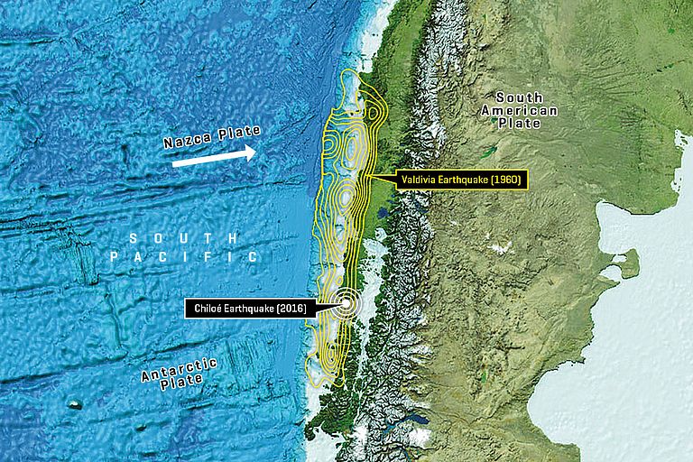
More than half a century later, on 25 December 2016, the earth was trembling around the southern Chilean island of Chiloé. With a strength of 7,5 Mw this event can be described as rather moderate by Chilean standards. But the fact that it broke the same section of the Chilean subduction zone as the 1960 earthquake is quite interesting for scientists. As researchers from the GEOMAR Helmholtz Centre for Ocean Research Kiel and the Universidad de Chile have now published in the journal Geophysical Journal International, part of the energy of the 2016 quake apparently dates back to before 1960. “So, the 1960 quake, despite its immense strength, must have left some strain in the underground, “ says Dr. Dietrich Lange, geophysicist at GEOMAR and lead author of the study.
To understand why Chile is being hit so frequently by heavy earthquakes, one has to look at the seabed off the coast. It belongs to the so-called Nazca plate, a tectonic plate, which moves eastwards with a rate of 6.6 cm per year. Off the Chilean coast it collides with the South American plate and is submerged beneath it. In this process, strains build up between the plates - until they break and the earth trembles.
During such an earthquake, the strain is released within minutes. During the 1960 earthquake for example, the plates shifted by more than 30 meters against each other. As a result, landmasses were lifted up or down several meters with a fundamental change of Chilean landscapes and coastline. "The scale of the slip also gives information about the accumulated energy between the two plates," explains Dr. Lange.
From the time interval (56 years), the known speed of the Nazca plate, and further knowledge of the subduction zone, the German-Chilean team has calculated the accumulated energy and thus the theoretical slip of the 2016 earthquake to about 3.4 meters. But the analysis of seismic data and GPS surveys showed a slip of more than 4.5 m. "The strain must have had accumulated for more than 56 years. It is older than the last earthquake in the same region," says Dr. Lange.
Similar results have recently been obtained in another subduction zones. Along with them, the new study suggests that for risk assessment in earthquake-prone areas, not just a single seismic cycle from one earthquake to the next should be considered. "The energy can be greater than that resulting from the usual calculations, which can, for example, have an impact on recommendations for earthquake-proof construction," says Dr. Lange.
Reference:
Lange, D. J. Ruiz, S. Carrasco, and P. Manríquez (2017): The Chiloé Mw 7.6 earthquake of 25 December 2016 in Southern Chile and its relation to the Mw 9.5 1960 Valdivia earthquake. Geophysical Journal International, https://doi.org/10.1093/gji/ggx514
High-res images:
The Nazca plate moves eastwards with a rate of 6.6 cm per year. Off the Chilean coast it collides with the South American plate and is submerged beneath it. In this process, strains build up between the plates - until they break and the earth trembles. Image reproduced from the GEBCO world map 2014, www.gebco.net
This photo shows earthquake damage in Valdivia (Chile) after the eartquake of 1960 (High-res image available on the website of the NOAA Centers for Environmental Information)
Contact:
Jan Steffen (GEOMAR, Communication & Media), Tel.: (+49) 0431 600-2811, presse(at)geomar.de


