Climate reconstruction: examples
Precise knowledge of past states of the climate, the ocean and the ice cover of the continents is the basis for understanding the natural mechanisms that drive the ocean-climate system. These past changes allow us to relate present and future human-induced changes to natural variations. This is the motivation for palaeo-oceanographic and palaeo-climate research at GEOMAR, which reconstructs changes in the ocean-climate system on time scales of centuries, millennia, or even millions of years, compares them with the present and thus underpins climate models that allow reliable predictions of future climate system developments.
Paleo-oceanographic research activities focus in particular on past climate states that were globally warmer than today by an annual average of 1.5 degrees Celsius (as in the so-called Eemian warm period about 120,000 years ago) to 4 degrees Celsius (in the Miocene about 14 million years ago) and thus lie within the range of predicted human-induced warming scenarios. Here, the focus of interest is particularly on the mechanisms that led to these warm phases. This includes both abrupt changes on time scales of years to decades, as well as changes that permanently changed the ocean-climate system to a different state. These include, for example, the multiple and varied changes between warm and glacial periods, which were primarily driven by cyclical changes in the Earth's orbital parameters and the associated changes in solar radiation on time scales of thousands to hundreds of thousands of years.
Decadal Climate Dynamics in the North Pacific and Atlantic: Using Proxies to Extend Instrumental Time Series
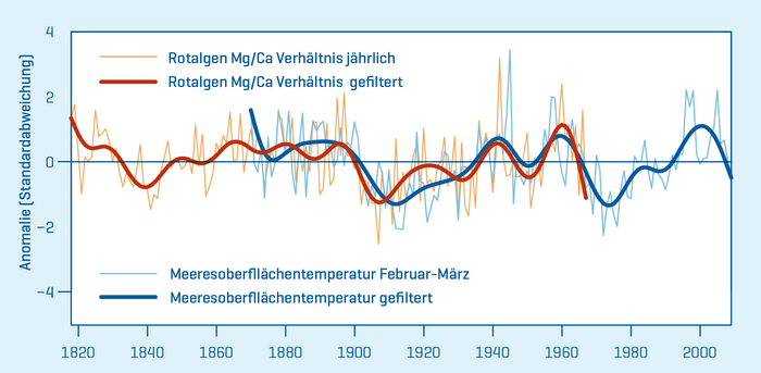
It is becoming increasingly clear that the seas of the Northern Hemisphere and their ecosystems are responding more intensely and rapidly to global warming than most other regions of the world. Instrumental records demonstrate decadal to multidecadal changes in the northern North Pacific Ocean during the 20th century, with significant impacts on the climate and marine ecosystems of the Northern Hemisphere. In contrast, knowledge of the longer-term evolution of natural ocean variability and climate dynamics is very limited due to sparse instrumental observations before 1950.
Long-lived and extremely slow-growing coralline red algae from the Aleutian Islands in the North Pacific are a valuable new marine climate archive that offers insights into the decadal interactions between atmospheric circulation and the North Pacific, as well as long-distance effects to the Atlantic, that reach back much further into the past than the instrumental data. Here, magnesium values in the growth fringes of coralline red algae are measured in high resolution and translated into regional sea surface temperatures (SST) via calibrations. This geochemical dataset represents the longest annually resolved SST proxy dataset from the subarctic North Pacific to date (1818-1967). The SST variation data obtained provide the first evidence for the existence of an atmospheric link between the sea surface temperatures of the northern North Pacific and the multidecadal variability of the Atlantic. These geochemical datasets, which go beyond the instrumental time series, from a new, extremely slow-growing climate archive thus offer the possibility to validate global climate model simulations in the climate-sensitive high latitudes.
Warm Climate Conditions in the Earth's Older History
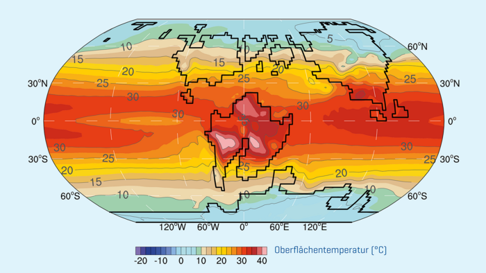
About 75 per cent of the last 500 million years were characterised by global warm periods with significantly higher atmospheric carbon dioxide concentrations than today. During these "greenhouse phases" there were no significant polar ice sheets. Today's bipolar glaciation is rather a special case in Earth's history. The understanding of extreme greenhouse climate states has increasingly become the focus of interest because the currently rapidly increasing CO2 concentrations in the Earth's atmosphere contribute significantly to human-induced global warming (status 2020: 415 ppm CO2 in the atmosphere). If there is no significant reduction in CO2 emissions, around 650 ppm will be reached by the end of this century.
Similarly, high CO2 levels, and thus the possibility of studying their effects on ocean circulation and ocean chemistry, heat and moisture distribution and other climate factors, existed only in older geological periods. In the Cretaceous period, which began about 142 million years ago and ended with the extinction of the dinosaurs and the expansion of mammals 65 million years ago, atmospheric carbon dioxide levels reached as high as 2000 ppm, which can be explained by the interaction of geography (plate tectonics, land-ocean distribution), vegetation, precipitation and the course of rivers, ocean currents, atmospheric circulation and marine biogeochemistry, leading to global temperatures that were up to 6°C higher.
Tropical Warm Pools: How did the Earth's Heating Systems Evolve?
Extensive areas in the west of the tropical Atlantic and Indo-Pacific are characterised by very high sea surface temperatures that are higher than 28°C all year round. These high temperatures reach down to several hundred metres of water depth and the thermal expansion raises the sea level by several decimetres. These so-called warm pool areas were and are important drivers of the global climate, as they have a lasting influence on both oceanic and atmospheric heat transport from low to high latitudes, as well as on the global hydrological cycle. The extent and intensity of the warm pools varies from year to year, along with the El Niño-Southern Oscillation (ENSO). However, they show extraordinary changes in recent decades, such as an increase in rainfall and tropical storms, which have a supraregional influence.
To be able to classify these changes, it is necessary to know how these warm pools have changed in the past within the framework of natural global and regional processes, what the controlling factors were and what the global impacts were. Research on the Manihiki Plateau in the tropical western Pacific, for example, shows a sustained change in the western Pacific warm pool. Distinct temperature gradients in the upper water mass layers until about 1.7 million years ago indicate a location of the west Pacific warm pool further east. Subsequently, a permanent westward shift occurred, which had pronounced effects on El Niño/La Niña events and thus on the tropical climate in the entire Pacific region.
Reconstruction of the Monsoon Rainfall History
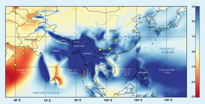
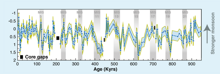
Months of heavy rainfall followed by six months of drought - the Indian monsoon, with its seasonally changing rainfall and wind directions, influences the lives of people around the Indian Ocean. It is of crucial importance for agriculture and thus for feeding several billion people. At the same time, its effects such as floods and landslides can have catastrophic consequences in densely populated areas. But how exactly does this important climate system function? And how does it change as the atmosphere continues to warm? For this purpose, the monsoon precipitation in the Indian Ocean was reconstructed. This showed that warming phases in the southern hemisphere and the transport of moisture across the equator to the north were an important control mechanism of monsoon intensity over the last million years. This information is important for realistic climate models and predictions of the future monsoon.



![[Translate to English:] x](/fileadmin/_processed_/e/e/csm_Humboldt_YingCui_493c68cd2c.jpg)
![[Translate to English:] Ein beleuchtetes Forschungsschiff im Eis in dunkler Nacht](/fileadmin/_processed_/c/3/csm_MOSAiC_c_SteffenGraupner_d5e6c4a5ce.jpg)
